Ryder 2019 Expedition Mapping uncharted waters of Northern Greenland where no ships been before
The main goal of the Ryder 2019 Expedition, aboard the Swedish icebreaker Oden, was to reach the unexplored Sherard Osborn Fjord where Ryder Glacier exits to drain approximately two percent of the 1.7 million km2 large Greenland Ice Sheet into the fjord. Ryder Glacier is a so-called marine outlet glacier. This means that the glacier originates in a larger ice sheet or ice cap and drains the ice towards the ocean, much like rivers drain a catchment on land. Ryder Glacier ends in a large, approximately 27 km long floating ice tongue, a feature that only exists today only on two other marine glaciers on Greenland; Petermann Glacier and 79° North Glacier. Several of Greenland’s marine outlet glaciers have lost their ice tongues during the last decades which is of great concern because these ice tongues act to protect the ice sheet from accelerated mass loss that can lead to global sea-level rise. Inflow of warmer subsurface water of Atlantic origin has been shown to be one of the main causes behind these losses. The warmer water reaches the glaciers and exert melting from below, which causes them to thin and easier break of icebergs, a process called calving. Ryder Glacier’s ice tongue extended about 50 km further out than today in 1917, when Danish geologist Lauge Koch and polar explorer Knut Rasmussen reached the Sherard Osborn Fjord by land during their Second Thule Expedition. Subsequent air photos reveal that it retreated to its present location sometime before 1947, implying that it has been relatively stable for seven decades, in contrast to the ice tongues of Petermann and 79° North glaciers, which both recently lost significant part of their extensions during major calving events. The primary scientific motivation behind the multidisciplinary Ryder 2019 Expedition was to increase our knowledge on the Ryder Glacier’s dynamics in particular and the cryosphere and ecosystem of Northwest Greenland in general, specifically changes that may occur in a warming climate. The different behaviour over the last decades of Ryder Glacier was one of the main scientific questions as understanding the rapid recent acceleration of the melting of the Greenland Ice Sheet has critical ramifications to our ability to model global sea level rise.
The primary scientific motivation behind the multidisciplinary Ryder 2019 Expedition was to increase our knowledge on the Ryder Glacier’s dynamics in particular and the cryosphere and ecosystem of Northwest Greenland in general, specifically changes that may occur in a warming climate.
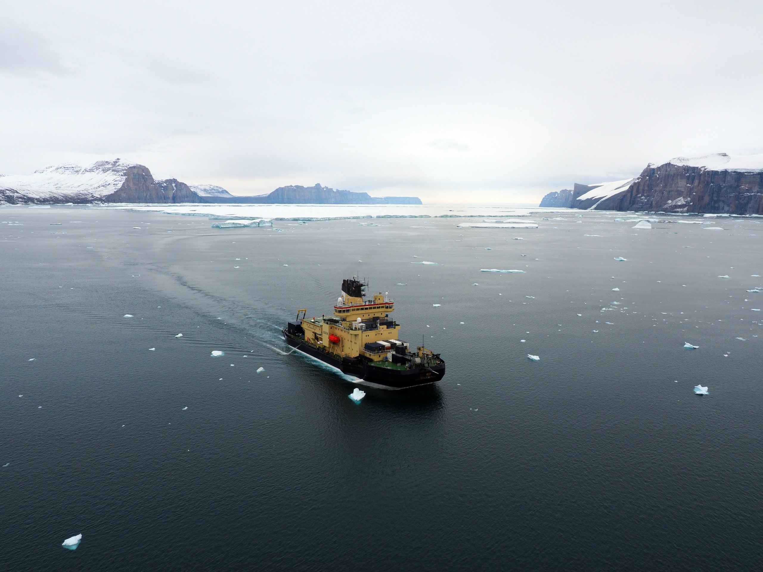
The expedition started from the harbor of US Air Force Base Thule, Northwest Greenland, on August 5, 2019. The scientific party of 39 included scientists from Sweden, USA, Canada and Denmark supported by experienced and skilled ship crew and logistical support personnel from the Swedish Polar Research Secretariat, two helicopter pilots and their mechanic as well as a medical doctor and nurse. The Ryder 2019 Expedition returned to Thule September 10 after 37 days scientific exploration and mapping of some of the most remote and previously unknown areas of the World oceans.
Qimera in the core of the processing scheme.
Mapping the fjord formed the basis for most of the marine research on the Ryder 2019 Expedition, and it was also a necessity in order to bring the icebreaker into the completely uncharted fjord. Bathymetry plays a key role in understanding whether or not amarine outlet glacier is sensitive to inflow of warmer subsurface water. Many fjords have shallow sills at their entrances, which could prevent inflowing warmer water from reaching the glacier to exert melting. Whether or not Sherard Osborn Fjord had a bathymetric sill was therefore one of the main questions the expedition set out to answer.
After finding a way through the often >4 m thick multiyear sea ice of the Lincoln Sea off Northwestern Greenland, we entered the Sherard Osborn Fjord by the evening of August 11. We had to carefully survey the seafloor using the multibeam echosounder installed on Oden in order to reach further into the fjord. The icebreaker drafts >8 m and weighs >10,000-ton and we did not intend to run aground! We had to drive a sinuous path allowing the outer beams of the multibeam sonar to “look ahead” of the icebreaker and determine if the depths were navigable. The geophysical mapping team consisted of six surveyors from the Center for Coastal and Ocean Mapping (CCOM), University of New Hampshire and the Department of Geological Sciences, Stockholm University. The team was led by Dr Brian Calder from CCOM, developer of the CUBE algorithm now an integral part of Qimera. It was critical that the multibeam data were processed more or less instantly after it was logged because the seafloor shape and depth are key parameters for deciding optimal sampling sites. Qimera formed the core of the processing chain. The concept of dynamic surfaces was particularly useful in this application as we often had to leave an area partly mapped and return to finish it later. The multibeam team worked in two-four hour shifts per day, with one surveyor assigned to the logging and one to the processing. The Ryder 2019 Expedition mode of operation was to map during the night and carry out sampling range of sampling operations (coring, water sampling, biological sampling, etc.) during the day. In addition, we had numerous land-based scientific programs (ecology, archeology, lake sampling, sea level studies, wood sampling, etc.) calling for almost daily, multiple helicopter flights to surrounding field areas.
It was critical that the multibeam data were processed more or less instantly after it was logged because the seafloor shape and depth are key parameters for deciding optimal sampling sites. Qimera formed the core of the processing chain.
Close to Manhattan sized icebergs challenge the operation in Sherard Osborn Fjord.
As we entered the Sherard Osborn Fjord we were faced with huge tabular icebergs, nearly 10 km in length and over 100 meters thick. They were close to blocking the entire fjord entrance, but we found a small pathway around them. These icebergs are remnants from previous calving events of the Ryder Glacier’s ice tongue. We do not yet know their ages, but considering that the thick prevalent sea-ice cover of the Lincoln Sea prevents them from exiting the fjord, the oldest are most likely the remains of calving events that broke up the ice tongue that previously extended 50 km further out in the fjord, as documented by Lauge Koch and Knut Rasmussen in 1917. The icebergs were constantly on the move as they drifted in the ocean currents and sometimes clustered to block the entire ~20 km wide fjord. By using daily satellite images and tracking transponders on the icebergs, we were able to work around the bergs to safely navigate in the fjord.
Scientific results.
The expedition results are now being looked at in detail, but in part due to our ability to rapidly and accurately process the multibeam sonar data, we already know the critical shape and depth of the seafloor in Sherard Osborn Fjord. There is not only one shallow sill, but two! This was indeed a surprise to us and may be the explanation for why the Ryder Glacier has behaved so differently over the last decades compared to the more southerly located Petermann Glacier. Due to the efficient processing onboard Oden we could immediately upon returning, contribute the multibeam bathymetry to the Nippon Foundation-GEBCO-Seabed 2030 project. The goal of Seabed 2030 is to map all of the world ocean by 2030 in support of sustainable uses of the oceans, seas and marine resources in alignment with UN Sustainable Development Goal #14. The Seabed 2030 project has taken over the work of compiling the International Bathymetric Chart of the Oceans (IBCAO), implying that the mapping data from the Ryder 2019 Expedition also are included in IBCAO 4.0, which is being released during the winter of 2019.